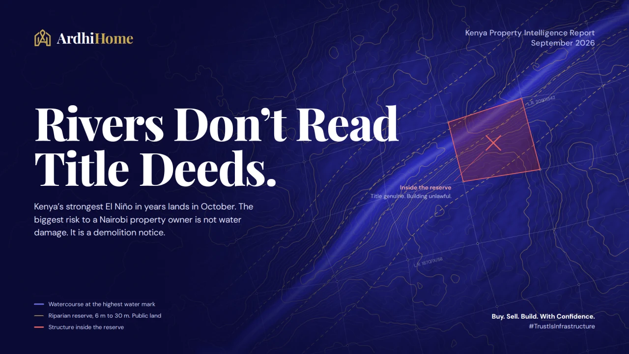
Kenya is weeks away from what forecasters expect to be a very strong El Niño. Every heavy season audits the property market — the rain finds the buildings that went up where they legally shouldn't have. But in 2026, the biggest risk to a Nairobi property owner is not water damage. It is a demolition notice. Here is what previous El Niños actually did, what changed this year, and the one due-diligence check almost every buyer skips.
Sources: Kenya Meteorological Service Authority, ICPAC, the Nairobi River Commission, Kenya Law, NEMA regulations, UN OCHA, the World Bank, and the ArdhiHome Kenya Property Market Index.
In about three weeks, the market gets tested
There is a version of property due diligence that stops at the title deed. Is it genuine? Is there a charge on it? Does the seller actually own it?
Those are the right questions. They are just not all of them.
Because a title deed will tell you who owns a piece of land. It will not tell you whether you are legally allowed to have a building on it. And every few years, Kenya runs an unforgiving audit that finds the difference. That audit is the rain, and the next one starts in October.
What is actually coming
The Kenya Meteorological Service Authority has been unusually direct. Its Head of Public Weather Services, Hannah Kimani, put the probability that the 2026 El Niño turns out to be very strong at 81%, and the probability it persists into early 2027 at 97%. The Niño 3.4 index — the standard measure of the event's strength — reached +2.7°C on 12 August.
In an outlook dated 26 August, Kenya Met forecast above-average rainfall over 80% of the country for the October–December short rains, with prolonged wet spells and occasional isolated storms. Rains are expected to begin in the second and third weeks of October across most of the country, and the third to fourth week in Machakos, Kitui, Makueni, Kajiado, Taita-Taveta and inland Tana River. Announcing the outlook at the 13th National Climate Outlook Forum, KMSA Director Edward Muriuki said to expect enhanced rainfall in most parts of Kenya. Regionally, ICPAC put a 90% chance of enhanced October–December rain over north-eastern Kenya.
Two honest caveats, because they matter more than the headline. First, El Niño is not rainfall — it is a Pacific warming pattern that shifts the odds. What decides how much rain Kenya actually receives is the Indian Ocean Dipole. The Narok County Director of Meteorological Services, Stanley Kinyua, put it plainly: 2015 was a very strong El Niño, close to 1997, but because the IOD was only weakly positive, Kenya did not get 1997-level rainfall. This year the IOD is expected to turn positive from September, with international models pointing to roughly +0.8°C to +1.1°C through October and November — which is the amplifying combination, not the dampening one. Second, forecasters remain split on exactly when the rains start, because the Madden–Julian Oscillation signal is unclear.
So: a high-probability strong event, an amplifier likely switching on, and uncertain timing. That is enough to prepare for. It is not enough to panic about.

What previous El Niños did to Kenyan property
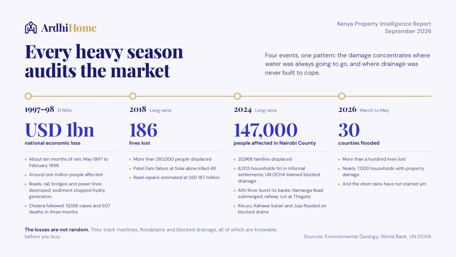
The 1997–98 event is the benchmark, and the numbers are sobering. Heavy rain ran for roughly ten months, from May 1997 into February 1998. Research published in Environmental Geology put the national economic loss at around USD 1 billion, with landslides destroying farmland, roads, railway lines, bridges, and telephone and power lines; eroded sediment clogged hydroelectric dams until generation stopped. Other estimates place the cost between USD 0.8 and 1.2 billion, affecting around one million people through damage to infrastructure, buildings and communications. The floods were severe enough that the World Bank approved a dedicated Kenya El Niño Emergency Project in June 1998, with roughly USD 18.9 million of it going to roads and bridges alone. Cholera followed the water: Kenya recorded 10,108 cases and 507 deaths in the first three months of 1998.
The pattern repeats at smaller scale whenever the rains are heavy. In 2018, floods killed 186 people in Kenya and displaced over 283,000, including the Patel Dam failure at Solai that alone killed 48. Road repairs were estimated at USD 187 million.
The 2024 floods are the ones your tenants remember. Nairobi County was among the worst affected, with roughly 147,000 people affected and 20,968 families displaced. In the city's informal settlements — Kware, Kibra, Viwandani, Mukuru Kwa Njenga, Kayole and Mukuru Kwa Reuben — some 31,000 people from 6,203 households were hit, and UN OCHA attributed it specifically to poor and blocked drainage. The Athi River burst its banks on 15 April and submerged homes in Machakos, affecting 443 households. In Kajiado, 275 households in Kitengela were affected. Houses in Kikuyu, Kahawa Sukari and Juja flooded because drainage was blocked. The Old Athi River bridge was severely damaged, the Namanga Road was submerged, and a landslide at Thogoto made the Nairobi–Kisumu railway impassable.
And this is not a historical problem. Between March and late May this year, floods affected 30 counties, killed more than a hundred people, and damaged nearly 7,000 households.
Notice what runs through all of it: the damage concentrates where water was always going to go, and where drainage was never built to cope.
The risk changed this year
Here is the part that matters most for anyone buying or holding Nairobi property, and it has almost nothing to do with getting wet.
After the 2024 floods, the government ordered the demolition of structures built on riparian land — the protected strip alongside rivers. Enforcement fell overwhelmingly on informal settlements. Bulldozers went through Mukuru and Mathare; three people died during the clearances; displaced families were offered the equivalent of about USD 75 to relocate, and human rights organisations condemned the process. Meanwhile, as the Daily Nation documented at the time under the headline "a tale of two laws for rich and poor," houses in Runda sat submerged and untouched, with one hotel pumping floodwater out of its compound using a small boat.
That asymmetry is now closing — and that is the single most important development of 2026 for property owners.
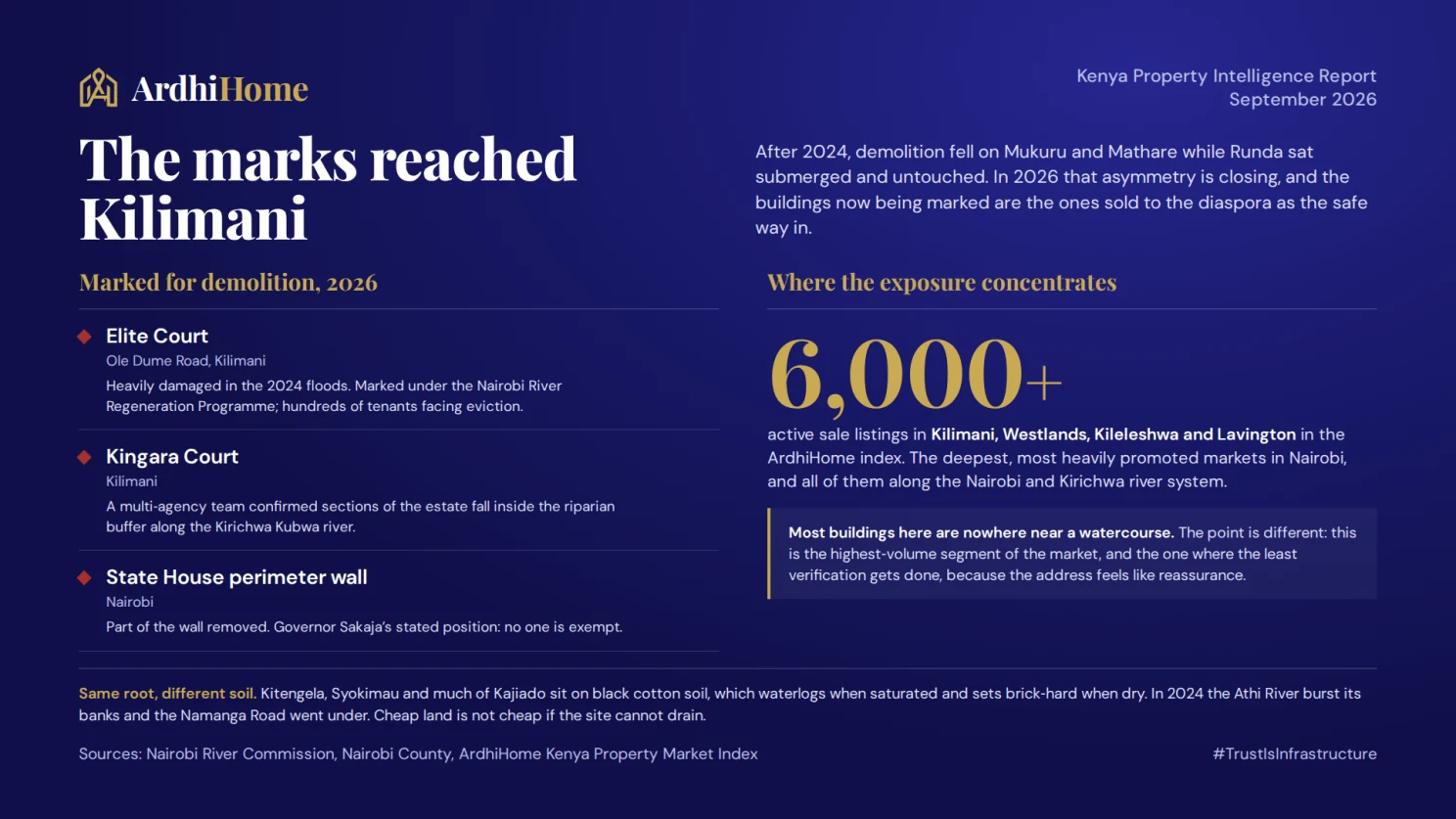
Under the Nairobi River Regeneration Programme, the Nairobi River Commission and Governor Johnson Sakaja have been marking buildings that sit on riparian land, and the marks have reached the upmarket estates. Elite Court on Ole Dume Road in Kilimani — an estate heavily damaged in the 2024 floods — has been marked for demolition, with hundreds of tenants facing eviction. Kingara Court, also in Kilimani, was marked after a multi-agency team confirmed sections fell inside the riparian buffer along the Kirichwa Kubwa river. Part of the State House perimeter wall was removed. Sakaja's stated position is that no one is exempt.
Read that again as a buyer. Not a shanty. Not a slum. A Kilimani apartment block — the exact kind of asset marketed to diaspora buyers as a safe, prestigious, income-generating entry into Nairobi property.
Nairobi County's own environment officer, Geoffrey Mosiria, has been blunt about the cause, saying flooding in areas like Parklands is not fundamentally a drainage failure but the result of developers building on riverbanks and squeezing the water out onto the roads.

What riparian land actually is
This is the part worth knowing precisely, because the confusion around it is exactly what buyers get caught by.
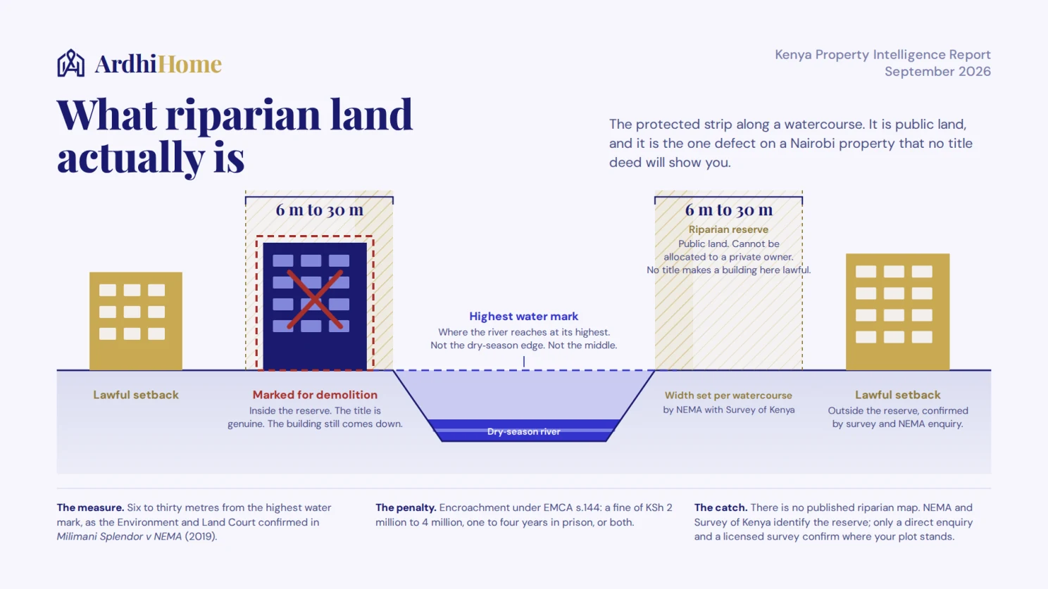
Riparian land is the protected strip along a watercourse. Under the Environmental Management and Co-ordination Regulations, it runs a minimum of 6 metres and a maximum of 30 metres from the highest water mark — the line the water reaches when the river is at its highest, not the river's edge on a dry day and not, as the Environment and Land Court had to clarify in Milimani Splendor Management Limited v NEMA in 2019, the middle of the river. The exact width within that 6-to-30-metre range depends on the watercourse.
Two consequences follow, and both are severe.
First, riparian land is public land. The Constitution treats rivers, lakes and the land between their high and low water marks as public property. It cannot lawfully be allocated to a private person. Which means no amount of paperwork makes a building on it legitimate — you can hold a title, a sale agreement and a stack of receipts, and the structure can still come down.
Second, encroachment is a criminal matter. Section 144 of EMCA provides for a fine of not less than KSh 2 million and up to KSh 4 million, imprisonment of one to four years, or both.
And now the practical problem that almost nobody talks about: there is no public riparian map you can check. Identifying and designating riparian reserve is a function of NEMA together with the Survey of Kenya, and as the law firm CMS has noted, establishing whether a specific property falls inside it requires making enquiries with those agencies, because the information has not been published. The courts themselves have flagged that the governing provisions across EMCA, the Survey Act and the Physical Planning Act conflict, and have called on Parliament to harmonise them.
So the single highest-consequence defect in Kenyan urban property is one you cannot look up, cannot see on a title deed, and will not be told about by anyone trying to sell you the unit.
Why this lands hardest on the most popular addresses
Our index makes an uncomfortable point here. The deepest, most liquid sale markets in Nairobi — the ones with the most listings and the most diaspora marketing aimed at them — are Kilimani, Westlands, Kileleshwa and Lavington, which together carry well over 6,000 active sale listings in the ArdhiHome index. Those same neighbourhoods sit along the Nairobi and Kirichwa river system. One of them, Riverside, is named after the feature.
Both estates marked in Kilimani this year are in that cluster.
This is not an argument against buying in Kilimani or Kileleshwa. Most buildings in these suburbs are nowhere near a watercourse and are entirely fine. It is an argument that the highest-volume, most heavily promoted segment of the Nairobi market is also the segment where riparian exposure is most concentrated — and where the least verification is typically done, because the address alone feels like reassurance.
The satellite corridor has a different problem with the same root. Kitengela, Syokimau and much of Kajiado sit on black cotton soil, which waterlogs when saturated and sets brick-hard when dry — punishing on foundations, drainage and access roads. In 2024 the Athi River burst its banks, the Namanga Road went under and the Kitengela exit was blocked. Cheap land is not cheap if the site cannot drain.
The honest counter-case
Three things cut against alarm, and you should hear them.
The forecast could underdeliver. If the IOD fails to strengthen as expected, this could look more like 2015 than 1997 — a strong El Niño that never translated into extreme Kenyan rainfall.
Enforcement has been inconsistent and legally contested, and it may stay that way. The riparian rules conflict across statutes, past demolitions have drawn serious human rights criticism, and the marking of upmarket estates may move slowly or stall in court.
And preparation is genuinely better this time. Nairobi has activated a multi-agency team spanning the Kenya Red Cross, KURA, KeNHA and county departments, with subcommittees on drainage, evacuation, shelter, security and communication, and crews clearing drains and river channels across all 17 sub-counties.
None of that changes the underlying point. A property either sits on riparian reserve or it does not, and that fact is true in a dry year too. The rain does not create the risk. It just reveals it — and gives the enforcers a reason to act.
What to do in the next three weeks
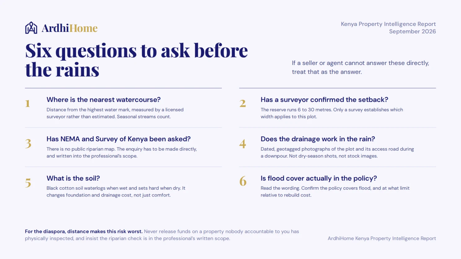
If you are buying, add one line to your due diligence. Before money moves, establish the property's distance from the nearest watercourse and whether any part of it falls within the riparian reserve. That means a licensed surveyor physically establishing the highest water mark and the setback, and enquiry with NEMA and Survey of Kenya — not a glance at a title, and not the developer's word. If a seller or agent cannot answer the riparian question directly, treat that as the answer.
If you already own, document now rather than later. Photograph the property and its drainage before the rains, make sure your insurance is current and actually covers flood, and clear culverts and channels on and around your plot. If you are near a watercourse, it is worth knowing where you stand before an inspector tells you.
If you are in the diaspora, this is the risk your distance makes worst. You cannot walk the plot after a downpour, and October to December is exactly when the ground truth is visible. Ask for dated, geotagged photographs of the property and its access road during the rains — not stock images, not dry-season shots. Never release funds on a property nobody accountable to you has physically inspected. Insist the riparian check is written into the professional's scope and reported back to you.
If you are developing or selling, get ahead of it. Buyers are about to become far more sensitive to this, and a development that can produce a survey showing clean setback and functioning drainage will sell faster and better than one that cannot. This is a documentation advantage, and it is cheap to acquire now.
The bottom line
Kenya is heading into what may be its heaviest rainfall in years, and the property market will be audited by it — as it was in 1998, in 2018, in 2024 and again earlier this year.
But the loss that ends an investment is not a flooded car park. It is discovering, after you have paid, that the building you bought sits on land that was never legally buildable, held by a title that could never have made it lawful, in a reserve that was never mapped anywhere you could have checked.
You cannot negotiate with a river. You can verify before you buy.
That is the whole business we are in: in a market where the most expensive defects are invisible, verification is the only real protection.

The ArdhiHome Kenya Property Intelligence Report is published monthly. ArdhiHome verifies agents, enforces listing standards, and gives buyers — at home and in the diaspora — the infrastructure to transact with confidence.
#TrustIsInfrastructure · Buy. Sell. Build. With Confidence.